
Tiger Mountain’s West No. 3 trail a good challenge for hikers | Column
Published 4:14 pm Thursday, July 24, 2008
Despite the weather-induced lack of a view at the Tiger Mountain summit, West Tiger No. 3 is a fun trail with just enough challenge in it to keep hikers interested.
I had read that the bald summit boasts great panoramic views of Seattle, but as I got closer to the top, it was clear the clouds were going to be an obstruction. Even so, it was rewarding to reach the summit and enjoy the interesting landscape the clouds provided.
The trail is easy to find. Simply take Exit 20, about three miles east of Issaquah, off of I-90 eastbound and turn right at the bottom of the ramp. You’ll almost immediately be at an intersection, take a right. Then follow the road (which soon turns to gravel) to the parking lot. There are no turnoffs or intersections, just a straight road to the parking lot.
From the parking lot, follow the signs to the hiking trails, then West Tiger No. 3. After you walk through a bike barrier, you are on the main trail and ready to go.
The first mile or so is a steep hike; it gets the calves burning right away. At that point the trail evens out to some degree, although it maintains a gradual uphill grade. Getting close to the top, there is a sign marking 0.6 miles to the summit. From then on, the trail gets more narrow and steeper. This is the hardest part of the hike, but it’s definitely manageable and you’ll want to power through the reach the top after making it so far.
The only bad part of the hike was the weather. It was cloudy and there was no view from the summit. In the final half mlle before the summit, there were a number of breaks in the trees that seemed like they would offer great views; but I couldn’t see past 20 feet due to the clouds.
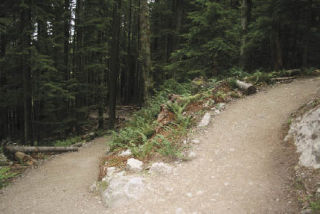
There’s plenty to see on the trail. A few small streams, interesting trees and small animals. There are only a few sun spots until closer to the top, as the trees are thick and green.
The trail surface is mostly smooth and wide enough for two to walk side by side for nearly the entire length. The entire trek up to the summit and back is more than five miles with about 2,000 feet of elevation. The summit elevation is 2,522 feet and the trail starts at 500 feet of elevation. It took me just over two hours for the round trip with just a couple of stops to take photos.
Close to the summit the trail intersects with the West Tiger cable Line. This looks like a trail (and does lead up to the summit) but there is a sign that warns against hiking on the path. It is a steeper climb and the rocks are loose compared to the rest of the trail.
Crowding wasn’t much of a problem, so without anybody so slow me down it was more of a power walk to the top. However, I did do the hike on a Tuesday morning, so it might be a different story on the weekend. Bikes aren’t allowed on this trail.
Adam McFadden can be reached at amcfadden@reporternewspapers.com or 425-255-3484, ext. 5054.