

As major flooding continues throughout Western Washington, data shows that areas along the Cedar River and the surrounding low-lying region in the Renton area are forecasted to reach moderate levels of flooding by 10 p.m. Wednesday, Dec. 10, and major flooding levels by 10 a.m. Thursday, Dec. 11, before receding as the day goes on.
As of 7:15 p.m. Dec. 10, flood levels were at 14.7 feet, which is within the moderate stage, according to the United States Geological Survey (USGS).
The National Oceanic and Atmospheric Administration (NOAA) reports that levels are moderate when they are over 14.5 feet and major flooding is over 16 feet.
The NOAA says that the impact of water over 14.5 feet means “the Cedar River will flood areas of Renton including the Renton Airport.”
If the water does get above 16 feet, NOAA says that “the Cedar River will cause major flooding in Renton, especially at the Renton Airport. Flooding will occur all along the river including headwaters, tributaries, and other streams within and near the Cedar River Basin.”
According to the King County Flood Warning System, the Cedar River is currently in phase 4, which means that severe flooding is expected.
Currently, the NOAA forecast calls for a peak of 17.5 feet at 10 a.m. Thursday morning, which would beat the previous record of 17.13 feet. This record was set over 35 years ago on Nov. 24, 1990.
Note: This article will be updated as needed.
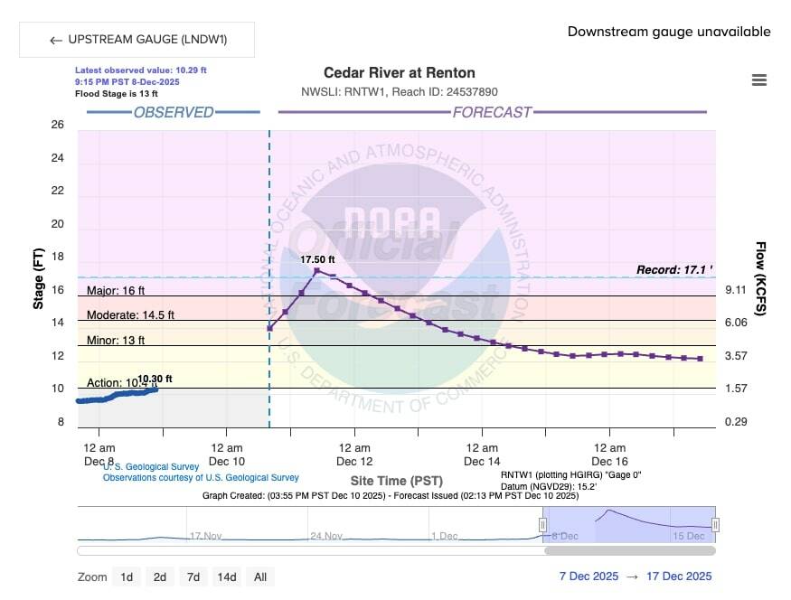
Projections show that flooding along the Cedar River may beat a 35-year-old record by 10 a.m. Dec. 11. Screenshot of National Oceanic and Atmospheric Administration Cedar River at Renton website page at 3:56 p.m. Wednesday, Dec. 10.